
map of the Econlockhatchee River near Kolokee Trail
While traveling at North Central Florida territory, we had many opportunities to see and reflect upon the great Welaka River or the River of Lakes as named by the Indigenous People at Florida territory. The common reference used today is “St Johns River” and this historic 310-mile river continues as one of few rivers flowing from south to north before entering the Atlantic Ocean. As you may or may not know, we followed its wondrous path, experiencing aspects of this iconic waterbody that are documented and shared under our presentment called “Welaka River Journey”. We hope you enjoy it.
The Econlockhatchee or "The River of Mounds"
During our Journeys of Appreciation, Jamal and I have observed numerous waterways connected to the Welaka within so-labeled "St Johns River" watersheds or basins, which include three major tributaries or smaller rivers: the Ocklawaha, the Wekiva, and the Econlockhatchee (the subject of this article). At 54.7 miles long, this River is the second largest tributary and referred to as the Econ River or simply Econlockhatchee. Personally, we think of it as "The River of Mounds" for reasons explained next.
Reportedly, First Nation People (descendants of the Yamassee from northern territories at “Georgia” and western territories at “Alabama” who were mislabeled as Creek and later became known as Seminoles), entered the Land of Flowers (“Florida” territory) and referred to the river as “earth mound river” or “mound river.” And the word Econlockhatchee, broken down in their language, is said to mean: 'ekena' for earth, 'laiki' for site or mound, and 'hatchee' for river or creek – notably due to the numerous mound-like formations along the river's bluffs and banks.
While reading this journal, please be mindful that the land mass compiling The Americas (or New World, as referenced by some historians) was attractive to other people from areas of so-named Europe. They emigrated from their countries to The Americas with intentions of continuing to impose their tyrannical greed systems upon the Original Inhabitants of this continent. Reportedly, an historical declaration at “Ellis Island” summarizes five “principles” and the first one begins, “CONQUEST – Despite the myth that the North American lay “empty” and available for the taking, European explorers encountered over 200 different cultures, whose ancestors had lived on this continent for thousands of years.” Another principle acknowledges exploitation and colonization by stating, “Euro powers claimed different parts of what would become the united states.” Native Americans (original copper colored people) inhabiting the land were experiencing its abundance and natural resources. So, any divisive terminology and associated practices imported by the conquistadors, invaders and immigrants have evolved into strategies designed to conquer, control, classify, conceal, and ultimately usurp birthright and heritage.
Also, you will notice that in our writings, we place quotation marks around or add 'so-called/so-labeled/so-named' before any words that infer ownership of people, places or things by colonizers. And we send much love and appreciation to Sister Rahsmariah Bey for her generosity in sharing the reference to “Ellis Island” and many other valuable resources available at www.rvbeypublications.com . In honoring our Mothers and Fathers, we are grateful for the opportunity to learn more truth which is ever-present. It is essential to Know Thyself as the lively descendants of First Nation People.

Econlockhatchee River approx. four miles west from the confluence of “Little Econ”
Parallels between the Econlockhatchee and the Welaka Rivers
The Econlockhatchee flows near three different “counties” (Orange, Seminole, and Osceola). Over the years, we have enjoyed seeing this scenic river at various locations and we noticed that it gets only the slightest bit of recognition in books and other mediums that tend to favor the Welaka. So, Jamal and I wanted to focus attention on the Econlockhatchee River as it travels along a meandering path to connect with that more prominent river.
Let's take a quick look at some similarities between these two rivers:
(1) Both evince thousands of years of existence by Original Inhabitants;
(2) Both are slow-moving and considered tannin-filled or blackwater rivers;
(3) Both start in the south, then head north before turning east.
(4) Sadly, both have endured years of dredging, channeling and impounding that impact the natural habitat, flow, water capacity, and healthiness.
There is another shared characteristic that is crucial: (5) They both receive love and appreciation from many people who care enough to protect and preserve their natural environments and significant longevity. We trust their passionate efforts continue to influence and compel "policy-making factions" to act more responsibly. Particularly in light of some of the hard-to-fathom tactics highlighted in item (4) that are increasing due to rampant complacency. We should consider the impact today's actions will have upon future generations. After all...We Are One with the Earth and Sky.
SYNOPSIS OF OUR ITINERARY
We did not experience every twist and turn along the Econlockhatchee River, which would have been a huge and delightful undertaking (perhaps we can do that later). Again, our intent was to see where it meets the Welaka and other waterbodies as well as the natural surroundings. The synopsis below helped us plan the itinerary for observing the 'confluence' (place where two or more rivers join to form one):
The Econlockhatchee River flows north from its reported headwaters at “Lake Conlin” through what is referred to as the “Econ River Swamp”. It is fed by smaller waterbodies along its northbound trek, including Fourmile Creek, Turkey Creek and Long Branch. Then joins the Little Econlockhatchee River, which is one of its two major tributaries (the other being referenced in some texts as 'Big Econ River') and flows for 17 miles through an expansive area called the “Little Big Econ River State Forest”. It then heads eastward to the Welaka River near what is known as Puzzle Lake, its confluence.
Some of you may be thinking...that doesn't sound like an arduous task. However, as dedicated documentarians, researchers, travelers, and having many other important responsibilities, each phase of the journey requires valuable time, boundless energy, and due diligence. The 'fruits' are worthwhile.
Beginning Our Journey of Appreciation
Jamal and I started out early one Summer morning (84-degree temp) to accomplish our goal as previously stated—following the Econlockhatchee River to where it meets the Welaka River. Initially, we envisioned just finding and documenting “Puzzle Lake” since we had already experienced the Econ on many other occasions and particularly during the Winter season (which I will discuss later). However, our minds changed when we came across road signage reading "Little Big Econ State Forest" and headed in that direction.
Upon arriving at the “Barr Street/Oviedo” entrance, it became pretty obvious why it's called a forest...trees, trees, and more trees. We paused briefly to scan a kiosk map to determine the most assured way to the river; then we grabbed a “trail brochure” and headed down the pathway. Right away we found ourselves surrounded by a dense array of trees (such as pine, oak, maple, sweetgum, sabal palm, and saw palmetto) that thrive within this natural community.

juvenile maple-tree “Little Big Econ State Forest”
It is said that there are 19+ different “community types”—including mesic hammocks, flatwoods, and varied wetlands such as swamps, marshes and bogs, sometimes described as areas that are entirely covered by water at least part of the year.
At first the trail seemed narrow and we paced single-file until it widened exposing a more traveled pathway with more open views of the dense forest terrain. There were colored markings placed on trees and I recall starting on the blue trail. Also, other signs with numbers posted. An explanation for how to use these 'Rescue Signs' for assistance is written inside the brochure. A pretty cool feature that only requires closer review of the entire map beforehand.

“Little Big Econ State Forest“ Summer season
Another fascinating thing that usually occurs during Spring and Summer—we hear the constant buzzing songs of cicadas emitting all around us. Like most people, we hardly see them. Mainly, this is the adult male mating call to attract females, who are mute. After mating, females lay between 200-400 eggs which begins the cycle of life for cicadas; however, afterwards females will live only 4 to 6 weeks longer. At “Florida” territory, it is said there are 19 species that can be identified by their particular song. Most of their lives are spent underground (2 to 10+ years) as young insects, feeding on sap from various roots until they emerge and shed their final skeleton. As adults their livelihood in trees and shrubs involves eating, calling, mating and flying, which lasts for only a few weeks before they perish. Every now and again, a chorus of songbirds chime in to lend their melodious voices to the atmosphere.
Before long we came to a short wooden bridge over a narrow stream that crossed the pathway in front of us. The surrounding forest changed to show a slight declining terrain along the stream; however, instead of tracking its origin, we chose to keep moving forward on the trail. We came to a natural intersection and had to make a decision...right or left. We liked the sign with the name “Kolokee Trail” and red markings were on the trees. Most of the way from here was under the midday sun and I was glad whenever the path veered under shady canopies. I found relief in the shaded areas while Jamal prefers being gifted by lots of sun.
Apparently, some colorful wildflowers appreciated the sun's generosity and the benefits of sandy soil along the trail (good drainage). We identified assorted plants and flowers that included:
(a) “Florida Tickseed” (Coreopsis leavenworthii), one of 13 in the species and genus coreopsis chosen as “state” wildflower. This perennial with bright yellow flowers attracts pollinators and butterflies, while songbirds and small mammals favor the seeds. Records show that some species were widely used by Native Americans as medicine, a vitamin-rich tonic or merely as vegetable food; the Seminoles used an infusion to relieve heat exhaustion. The coreopsis genus is thought to relieve stomach ailments, regulate metabolism, create dyes, and repel insects.

Florida Tickseed “STATE“ wildflower
(b) Partridge Pea (Chamaecrista fasciculata) is also called sensitive plant, sleeping plant, prairie senna, dwarf cassia, etc. It may be featured in an upcoming “Plant of the Moment” series. Partridge peas are an important honey plant. Nectar is made in orange glands at the base of each leaf--not in the flower—ants hang out here too. They are attractive to pollinators like bees and butterflies. They are larval hosts for sulfur butterflies and are a food source (seeds) for many birds and animals including deer. Partridge peas provide shelter (sturdy stems) for small mammals and birds. This plant can be used to control erosion and they improve soil fertility using the process of nitrogen fixation. Medicinally, Original Inhabitants used roots to keep sports players from tiring. Infusions are made for fainting spells and partridge pea is also used as an anti-emetic to treat nausea.

partridge pea or sensitive plant Econlockhatchee River upper banks Summer season
We also noticed an abundance of the usual cast of climbing greenery, such as air potatoes, wild grape leaves, and greenbrier (Smilax species). Here are a few other interesting plants that we observed and which required latter research:
(1) “Golden Polypody” (a.k.a., cabbage palm fern, gold foot fern): This epiphytic fern usually attaches itself to the boots of cabbage palms for support yet does no harm. We recently observed it on the trunk of a date palm. It reproduces by rhizomes, spreading by roots that are densely covered by golden scales (hairs)—hence its name. It is often grown as a houseplant as well. Ever since identifying it, we now see how prolific it grows in pine flatlands, oak hammocks and swamps. It is native to the Caribbean, Mexico, Central and South America, Asia, and Australia. There are numerous benefits of polypody such as uses for respiratory, digestive, and skin health; studies show it might treat Alzheimer's and dementia. Side effects have been reported, so diligent research is required before utilization or consumption.

golden-polypody Kolokee Trail near Econlockhatchee River; Summer season
(2) “Carolina Ruellia” or Carolina Wild Petunia: These beautiful, lavender trumpet-shaped flowers last for only one day, yet their flowering period starts in early Spring through Fall. We couldn't help noticing these self-seeding “Florida” natives colorfully decorating the trail. What a delightful treat for us, as well as butterflies, insect pollinators and songbirds. Also, it is native to other “states” at the southeastern region and some say it extends to Indonesia and Malaysia, Africa, Brazil, Central America, and Pakistan. Ruellia plants have traditionally claimed medicinal uses to treat flu, asthma, fever, bronchitis, high blood pressure, eczema, and diabetes. Research sources stated, “further work required is to isolate and characterize the active compounds responsible for these activities in this plant....” We encourage readers to seek expertise before using any plant medicinally or as edibles.

Carolina Ruellia “Little Big Econ State Park Kolokee Trail”
(3) “Common Elephant's Foot” (“Elephantopus elatus”): This plant caught our attention right away. We eat a lot of vegetables and anything that looks like edible greens for a big salad gets a second look. On the ground was an interesting rosette or leaf cluster—hence the name for the plant's large base or foot. The leaves have a thin white vein running down its center, which was also a curious feature. Then, a straight hairy stem (maybe 4 or 5 inches tall) appears to come from the middle of the cluster with small green disks (called 'florets' that become lavender to white) that are attached by three small hairy leaf-like bracts. Later we learned these are the plant's known characteristics. It is said to be native to “Florida” and southwestern “states” as well. As a perennial plant, it enjoys habitats like pine lands and open woods; it is drought tolerant and various pollinators like it.
Medicinally, this plant has cytotoxic properties due to the presence of two chemicals specific to the genus. Scientific evidence is contained in a document entitled “Tumor Inhibitors XL.1a The Isolation and Structural Elucidation of Elephantin and Elaphantopin, Two Novel Sesquiterpenoid Tumor Inhibitors from Elephantopus elatus.” No reports indicate whether this plant could be consumed by humans, so remember to seek expertise before foraging.

common-elephants-foot upperbanks of Econlockhatchee River
(4) “Dense Spike Blackroot” or “fox-tail” (“Pterocaulon pycnostachyum”): This perennial is native to “Florida” and southeastern territories. There seem to be other plants with some of its characteristics (like dandelion and lizards tail). Despite being strange looking—pollinators find them attractive. One writer described this plant as follows: “with stems winged with tissue undercurrent from leaf bases, and terminal, thick, flowing “cone-like” spikes. The upper surfaces of leaves are green, the undersides white with short cottony hairs. The narrow creamy white heads form a dense spike with no ray florets.” Our picture clearly shows that...Am I right? And reportedly, it has black roots which support food storage for its survival through drought periods. Wow.
Further, research of “species of the genus “Pterocaulon” (Asteraceae) found them used in different parts of the world for treating skin and liver diseases, disorders of the respiratory system, and others. They are a rich source of sweet-smelling 'Coumarin' which is added to fragrances and cosmetics; is naturally present in many foods like cinnamon, strawberries, cherries, celery, apricots and green tea; and is used in the production of blood thinners like warfarin and coumadin. With all the associated health benefits (often used in Ayurveda and Traditional Chinese Medicine), there are still precautions against excessive usage. Past studies have shown coumarin to cause liver damage, brain impairment and tumor formation. Please do your own due diligence.

dense-spike-blackroot near Econlockhatchee River; Kolokee Trail
(5) “Frog Fruit” (Phyla nodiflora) a.k.a., Turkey tangle fogfruit, matchhead, carpetweed, and capeweed – Another attractive wildflower that grabbed our attention as a fast-growing, dense, ground cover. It has distinctive tiny white and purple flowers posing around a dark purple cone that emerges from a single stalk (resembling matchsticks). The green leaves are opposite on stems that lie flat and have root nodes. We learned that Frog Fruit has nothing to do with frogs or fruit; however, they provide nectar for plenty of bees and small butterflies, and are larval hosts for other butterflies. Medicinally, it is often used to treat snake bites, digestive ailments, skin conditions, fevers, coughs and colds, and more with its antibacterial and anti-fungal properties. Remember to seek expert advice before using for healthful reasons.

frog-fruit-plant-groundcover- “Little Big Econ State Park” Summer season
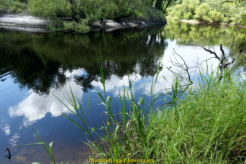
Continuing along the sandy trail, we were determined and curious to know when the river would be visible. That is until what looked like ravines appeared on the right-hand side. Our steps quickened as we explored nearby terrain and noticed signs of water streaming. Yes, it was definitely coming from around the bend and below somewhat of a high bluff. Jamal talked to a man who was kayaking on the river. He explained that he had already kayaked about eight miles that morning and that we were about four miles away from where the Big and Little Rivers merge. We shared that upon leaving this spot, we were headed to where the Econlockhatchee and Welaka Rivers unite. We explained what the word Welaka meant and offered more information about its path and flow. He got excited and acted as if he was going to kayak there shortly after our conversation. We explained that it was a good distance away even via car. He explained that he planned to kayak another twelve miles before heading back. We thanked each other for information shared and watched as his skillful navigation resumed.

Econlockhatchee River “Little Big Econ State Park Kolokee Trail“ Summer season
We spent a few moments marveling at panoramic views of the river. White clouds and blue sky was mirrored on top the shiny surface of the dark water, which also reflected a wide array of stately trees and vegetation. Some trees graced lower levels of bedrock in the forefront, while others stood on higher elevations in the background. Even the tannin-rich water added its own subtle beauty to the scene by forming unique ebb and flow patterns in the light sandy soil bordering the riverbank. This river has its very own majesty.
Returning to the entrance and reflecting upon our memorable experiences, we spotted a small gopher tortoise moseying along the path ahead of us. We paused to bestow adoring gazes and it paused too—seemingly to ignore us; so we continued strolling past. These animals are very gentle, always appearing to mind their own business. We have observed many of them (much larger versions), especially in sandy soil along forest hammocks where they diligently burrow deep homes for themselves and provide safe shelter for other small animals too.

gopher tortoise “Kolokee Trail”
By the way...did you know that April 10th has been declared "Gopher Tortoise Day"? Neither did we. The Gopher Tortoise Council has chosen this day (yearly) to "increase awareness and appreciation for these peaceful reptiles, and they encourage getting involved in efforts to protect them. The gopher tortoise has a fascinating life story that is delightful to study. Hopefully, you'll be inspired to share it with family and friends.
Staying with the itinerary and taking in beautiful rural settings near "Geneva," the GPS device we were using displayed lots of waterways, including "Lake Harney," a 6,000-acre lake sourced by the Welaka River. Continuing along "SR-46" towards "Mims" and enjoying more scenic rural views, we were looking for the "Hatbill Road" boat ramp which is where "Puzzle Lake" is located. Soon enough the terrain changed into long rows of embankments on both sides of the road and it looked as if we were heading in the right direction. We crossed paths with a worker driving a tractor, busily packing and smoothing the dirt on the somewhat narrow road – otherwise this would have been a bumpier, dustier journey.
At last we arrived and were greeted by terrific views of “Puzzle Lake” and the Welaka River, branching out in varied directions and framed by land surfaces. Some of them resembled small islands, filled to capacity with vegetation and tall grasses. This was unexpectedly impressive. I don't recall feeling this way about being close to a confluence—usually we are observing from a position off in the distance or experiencing the natural meeting points while on a boat (like cruising along the amazing Silver and Ocklawaha Rivers).
We marveled at this wonderful maize-like setting from the shoreline. There was a lone bamboo chair (weather-worn and broken) nestled in the light colored, sandy soil near the river. I envisioned myself (or anybody) sitting at this spot for hours, peacefully admiring this spectacular panoramic view. Just glance around, close your eyes and feel the different shapely clouds slow-dancing with the blues of the sky; listen as birds and small creatures express gratitude for this bountiful marsh habitat; appreciate the harmony between plants and tall grasses snuggling behind well-carved sturdy banks that have been sculpted as these waterbodies merge and flow in many directions. Ah-h-h...life is good.

“Puzzle Lake“ Welaka River confluence (lower water level) Summer season
We strolled around the dock area, observing the sandy terrain with various ground cover plants that included fleabane (daisy lookalikes), frog fruit (tiny white flowers around a dark, purple center), and Mexican clover (little star-shaped white flower with pinkish tips).

Mexican clover at “Puzzle Lake“ Welaka River confluence Summer season
Also, observed were yellow primrose willows, dogfennel and field thistle (some growing about 8 ft tall). Two parked trailers signified that boaters were navigating the waters, even though a pleasant gentleman (relaxing in a camper van), stated that the water levels were still about two feet low due to lack of rain. There was two men fishing along the riverbanks and the older of the two complained that they hadn't got a bite yet. The younger seemed happy just to be there.

“Puzzle Lake“ Welaka River confluence Summer season
After embracing the natural surroundings at "Puzzle Lake" for awhile, we went off-route to observe another waterbody that was new to us..."Loughman Lake". This attractive 649-acre lake is located a few miles west of "I-95" on "SR-46 and is connected by "Snake and Shad Creeks". Reportedly, these two creeks provide access to other waterways, including the Welaka River. Jamal was able to capture a beautiful lake scene featuring palm trees and tall grass along the shoreline around rippling waters and billowy white clouds defining a blue sunlit sky.

waterbody near “Puzzle Lake” Welaka confluence Summer season
We briefly paused again along SR 46 at a boat launch referred to as "C. S. Lee Park" located at "Geneva." Under beautiful cloud-filled blue skies, we enjoyed some more peaceful views of the Welaka. What a wonderful way to close out our Journey of Appreciation of the Econlockhatchee River.

Welaka River near “Seminole and Volusia Counties”

map of Welaka River near “Volusia County and Seminole County“ border
Before ending this journal entry, though, we feel it appropriate to highlight some of the locations mentioned earlier in the synopsis (itinerary), which includes notes gleaned from various research sources and our personal commentary:
Econ River Swamp: This 13-mile long swamp known as the upper course of the Econlockhatchee River is southeast of "Orlando" at "Orange County" and runs from “Lake Conlin” to "SR 528." To the south, the swamp becomes known as "Cat Island Swamp" and the river widens here bordered by "Lake Preston" to the west and has downstream elevation noted at 62 feet. Lakes "Mary Jane" and "Hart" connect to the swamp via so-called "Disston Canal." An arm of the swamp (so-named Turkey Creek Bay) forms another tributary of the Econ River called "Turkey Creek." The River exits the swamp north of Wewahootee Road, resuming its peaceful trek to the Welaka River. We have not experienced this location and look forward to doing so in the future.
“Lake Conlin/Conlin Lake X (CLX)”: A mostly undeveloped 1,400-acre lake located at "Osceola County" near so-named Saint Cloud. It is said to be surrounded by an area designated as "CLX Project" that is supposed to "increase the protection of biodiversity at the species, natural community, and landscape levels." It seems that long ago, the owner of “Mercury Marine” created the name “Lake X” to mystify its location and purpose of motorboat development and testing. Reportedly, the “Kirchmann Foundation” offers natural resource education classes and summer camp activities for youths at a 10,426- acre ranch “site”.
Little Econlockhatchee River: Often referred to as a stream, this 20-mile long waterbody originates near "Orlando" at southeast "Orange County" and runs through areas of "Seminole County" ending near "Oviedo" (its mouth) where it joins the larger Econ River on its journey flowing east to the Welaka.
Recalling pleasant memories, Jamal and I took an enlightening Wild Foraging Class at Jay Blanchard Park, located alongside the Little Econ River where we observed many aquatic plants, small animals and birds. The expert named Green Deane graciously shares his knowledge about edible plants, herbs, and trees. What a delightful 3-hour learning adventure.
Little-Big Econ River State Forest: Located at "Seminole County" and encompassing 10,336 acres of varied natural communities. Some records declare that the forest's name combines the little and bigger Econlockhatchee Rivers. Also, brochures reiterate that the Muskogee translation of Econlockhatchee was "river of many mounds" and Indigenous People "named the river for the multitude of man-made earthen mounds along the waterway." The Econ River runs 17 miles through the lower part of the forest, which protects natural communities and floodplains, supporting wildlife such as gopher tortoise, bald eagle, alligator, and wood stork. Additionally, archaeology surveys have documented seventeen significant sites (most of them are Indigenous mounds).
Puzzle Lake: The lake's name befits the situation that develops when the waters recede during seasonal weather changes. Many books tell the story about the well-known writer who was lost for hours on this lake. Even experienced boaters tell about difficulties navigating previously familiar routes due to changing water conditions. And it is said that the ecology is affected by ancient marine salt deposits. The lake forms the border between "Volusia and Seminole Counties" and the mouth of the Econlockhatchee River is situated to its north. Reportedly, an Indigenous Mound (so-labeled "Baxter Mound") still stands near a location documented by the well-known Bartram family botany team. There may also be other mounds around the lake.
Econlockhatchee Sandhills Conservation Area: As mentioned earlier, Jamal and I viewed the Econlockhatchee River during the Winter season and embraced its natural assets. Reportedly, the area encompasses 706 acres of varied plant and animal habitats and protects 2.5 miles of floodplain swamp. We began following the 'red' trail as noted on a map; however, we decided to veer off to the road traveling along the power lines, which at times lead to water. That choice took us on a lengthy yet fascinating walk past a density of trees and shrubs, including turkey oaks with striking red-orange colored leaves, sabal palms and tall pines on both sides of the road with seasonal ground cover plants and wiregrass at intervals. We were thrilled to begin seeing marshy terrain, where we noted small pools of water amid the trees and vegetation. We kept going until there was no doubt we were approaching the Econlockhatchee River. The road ended at this point and afforded nowhere to go except to follow a foot path alongside the river, which of course we did. We observed many leafless cypress trees with knees exposed as well as other fallen tree trunks, resting in the dark water with slow movement, surrounded by low surface elevations and visible white sand banks. We're glad to be so tenacious—this was such a rewarding experience.

Econlockhatchee River “Sandhills Conservation Area” - Winter season

CLOSING THOUGHTS
These travel journal entries are yet another way to share our Journeys of Appreciation to honor the Legacy of First Nation People, which encompass the ancestral land and life forms that co-exist upon it. We see it as a wonderful opportunity to follow our passion, while living our dreams, and respecting our parental. Being ever thankful for these experiences and delighted with our achievements thus far, we recognize that there is still much to be done. It remains our responsibility to seek, acknowledge and share universal truth.